Indro Robotics Drones Carried Out Thermal Missions in August For The City Of Kelowna
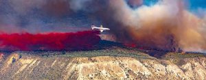
Photo shows some of the devastation wrought by the Okanagan fires this summer
KELOWNA – Devastating forest fires striking West Kelowna and parts of Kelowna meant all hands were on deck to join the fight, as over 30,000 people were evacuated from their homes with thousands of others on alert, and just under 200 homes and buildings were burned.
The City of Kelowna enlisted the services of Victoria-based InDro Robotics to assist in damage assessment by flying drones in the affected areas and carrying out thermal missions. The first flights were deployed on August 21.
“We wanted to leverage the potential of drones to gather critical information that can’t be obtained through other means,” says Jazz Pabla, Kelowna’s Director of Information Services. “This mission also worked closely, and with the full support of, Kelowna’s Fire Department.”
The Regional District of the Central Okanagan Emergency Operations Center contracted InDro Robotics to capture drone footage of the Clifton-McKinley fire area. Flights were coordinated and authorized through the Emergency Operations Center.
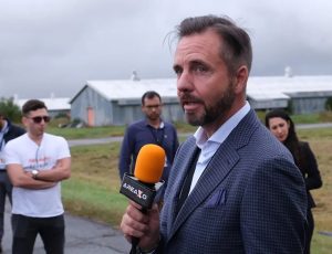
Indro Robotics CEO Philip Reece
“With a rapidly changing situation, decision-makers need the best available data,” says Indro CEO Philip Reece. ‘The thermal data will be useful – as these subterranean fires, which can smoulder for days and even weeks, are not visible to the naked eye.
”The thermal imagery captured by drones improved firefighting by providing precise data on underlying fire threats. Marking specific hotspots on maps where the ground temperature exceeded safe levels allowed responders to pinpoint exactly where fires were burning underground, ensuring a more effective and targeted response. In addition, the footage allowed Emergency Operations Center staff to share imagery with directly impacted property owners, allowing them to understand the magnitude of the damage before it was safe to allow re-entry.”
InDro carried out thermal missions over the city landfill, which was burning beneath the surface. A FLIR sensor will identify hot spots for those involved with fire management.
In addition, InDro will be flying missions to assess damage and pull together high-resolution photogrammetry.
Plans included using the Spexigon platform for those missions.
“We were obviously keen to help as quickly as possible,” says CEO Philip Reece. “To complement our own expertise, I felt that Spexigon would be the most suitable platform for rapidly gathering high-resolution imagery.”
The Spexigon platform simplifies the acquisition and processing of high-resolution earth imagery using most popular drones, and the software standardises the capture to produce imagery at scale.
That process begins with Spexigon capturing and indexing raw drone imagery. The imagery can then be used by the SpexiGeo software (or other third-party platforms).
Spexigon automates the flights, while the pilot’s job is simply to monitor the airspace like a visual observer, although manual control can be taken over at any time. This automation results in greater accuracy when capturing data over targets of interest and produces a database that can easily and securely be accessed by decision-makers.
“Obtaining high-resolution photogrammetry requires precise flying – including maintaining a consistent height above ground level,” says Reece. “The automated flights will ensure consistent photos – which will provide decision-makers with a clear picture of what’s been damaged, and to what extent.”
The Spexi app provides access to multiple features, including: Planning tools for efficient and accurate data acquisition; Autonomous flight using the latest DJI drones; Secure, cloud-based footage processing and sharing; and Survey work using Ground Control Points.
The spectacle of the raging fires unfortunately drew some unwanted attention, as officials say unauthorized drones flights took place with people posting video to social media.
The presence of drones not directly related to emergency operations is both illegal and dangerous. Water bombers and helicopters are in regular use and drones can pose a threat to those operations.
“Drones are a significant hazard to our air crews fighting fires,” said Bruce Ralston, BC’s Minister of Forests. “Now is not the time to take the footage or photos of active wildfires. Not only is it irresponsible, but it is illegal to fly them in fire areas.”
InDro is working closely with Kelowna emergency operations to ensure any drone flights do not pose a conflict with crewed aviation.
“This will be an ongoing operation and we’ll obviously be taking great care to ensure any InDro-operated flights are well clear of other aerial firefighting operations,” says Reece
The wildfires are obviously of serious concern, and InDro hopes to make a meaningful contribution to those involved in emergency response.
“Drone-gathered data – whether thermal or visual – helps those in charge make the best possible decisions in a rapidly changing situation,” says Reece. “We will fly missions as long as required, and offer any other assistance we can. We hope the situation for the tens of thousands of people impacted by this disaster returns to normal as soon as possible.”
By Mark MacDonald
